


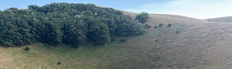


If you love bright colors and walking in the open air, a hike around Mount Cucco is for you. This peak is located a stone's throw from the ridge of the Apennines and its name would seem to derive from the particular karst morphological conformation: "Cucco" means "to be hollow inside." Since 1995 the area consisting of the municipalities of Costacciaro, Fossato di Vico, Scheggia and Pascelupo, and Sigillo has become a protected area, thus giving rise to the Mount Cucco Park.
The particular microclimate of the area makes the Park's vegetation lush: meadows and woodlands cover the area and the eastern slope contains centuries-old specimens of beech, maple, holm oak, chestnut, yew and hornbeam. If you are careful on your walks you can also see some specimens of white spruce, a native remnant of the ancient Apennine forest cover.
The area is also an ideal home for the wild animals that populate it: in addition to foxes, wolves and wild boars, with a little luck you may come across fallow deer, roe deer and birds of prey.
Thanks to its trails, Mount Cucco Park can be visited almost entirely on foot and offers several trekking routes within everyone's reach with varying durations and levels of difficulty.
Below are some of the most exciting ones.
ITINERARY 1: THE SPACCATURA DELLE LECCE
| Departure | Sigillo |
| Length | 2.5 km round trip |
| Height difference | 200 m |
| Travel time | 2 hours one way and one hour return |
| Diffifulty | E-hiking |
The Spaccatura Delle Lecce opens inside an imposing rock face, a real stone wall, so massive that, at first glance, it is almost incomprehensible the precision with which it is torn, in its center. Legend has it that such an opening, some 70 meters high, was created by the god Vulcan-ancient Roman god of fire and metalworking-who had his own forge for making weapons right on Mount Cucco, while testing the force of a blade commissioned to him by Jupiter causing the rock to break.
Such a spectacle of nature is now the central stage of path 238, which allows one to best admire the extraordinary nature of the landscape it dominates.
Leaving by car from Sigillo, one climbs for about a kilometer in the direction of the hamlet of Val Di Ranco, until one finds the entrance to the trail. Once the car is parked, one begins the adventure on foot. Skirting the Torrente delle Gorghe, one arrives in the wooded valley from which the view of the Spaccatura delle Lecce gradually widens.
The trail continues up the gorge for about 700 meters along the opposite side. Along the way you can admire fascinating, sturdy trees climbing up the rock face-primarily holm oaks, boxwoods, and laurels-and in the summer season the greenery is tinged with lilacs as bluebells bloom. In the course of the walk one also comes across the temporary spring of the Lecce, an opening in the limestone rock that in time of rain originates a fan-shaped jet of water. Finally, walking for a short distance along the asphalt road that connects Sigillo to Val di Ranco, to reach the end of the trail (not far from the starting point), it is possible to take a detour that allows you to stop at a viewpoint exactly above the rift!
Be sure to bring a water bottle or better yet, a reusable water bottle because no drinking water can be found along the trail.
The route is not recommended in case of heavy rain.
ITINERARY 2: TOUR AND SUMMIT OF MONTE CUCCO
| Departure | Sigillo |
| Length | 6.5 km round trip |
| Height difference | 370 m |
| Travel time | 4 hours |
| Difficulty | E-hiking |
Panoramic views, hang gliders in flight, fossil remains, a karst spring in which to fill up with fresh water, unusual species of flowers and, on the clearest days, the Adriatic Sea: these are just some of the charms of the trekking route that winds its way along three paths to the summit of Mount Cucco.
The starting point is located along the road from Sigillo to Val di Ranco. Once you have parked your car a few steps away from an area dedicated to hang gliding enthusiasts, you take path 226, not so steeply inclined. It is a walk of about 800 meters before meeting the detour for path 240, which climbs gradually, giving views of the valley crossed by the Chiascio River and the hills around Mount Cucco. As you change altitude, the grass on the path gives way to rock and fossils embedded in it like precious stones, 200 million years old, when there was a sea instead of the Apennines. In fact, by picking up a few stones, it is possible to recognize the remains of carbonate sand from the tiny white grains.
Before reaching the summit, you also encounter the Ghiacciata spring, a drinking spring of karst origin, and continue into the forest of beech and maple trees, which cool and shelter from the sun, especially on summer days. Coming out of the woods, you take path 239 on the right, after a small exposed section, which finally leads to the summit of Mount Cucco, 1566 meters high. The view is breathtaking: the Sibillini Mountains to the south, Mount Catria and Mount Nerone to the north, Mount Conero to the east and Mounts Argentario and Amiata to the west. In addition to looking around, it is worth looking up to catch a glimpse of hawks, sparrow hawks and buzzards in flight, but also, depending on the season in which you take the route, to look on the ground for flowers such as the red lily, primrose and poetic narcissus. After having had your fill of beauty, to turn back just look for path 226, which you follow to the right and has one last surprise in store: the entrance to Mount Cucco Cave. The section is particularly steep and slippery and can pose a difficulty for the unaccustomed.
Path 226 finally leads to the starting point of the hike.
There is a particular difficulty of the trail on the downhill section from the top of Mount Cucco to the entrance of the Cave, due to the steep slope and the presence of treacherous and slippery rocks.
ITINERARY 3: THE VALLEY OF PRISONS
| Departure | Coldipeccio |
| Length | 9.5 km round trip |
| Height difference | 400 m |
| Travel time | 6 hours |
| Difficulty | E-hiking |
Although the name of this route leads one to think of a place of enclosure and austerity, the unspoiled nature of the Valley of Prisons leaves anyone who crosses it with a sense of freedom and peace. A long, difficult, almost atonement-like journey. In fact, the area had been chosen by hermit monks, to whom the valley was named, as an ideal site for prayer and meditation.
The trekking route starts from the village of Coldipeccio, where you can park your car and then take path 232, uphill, surrounded by greenery that alternates with views of the karst rock that characterizes the entire Mount Cucco Park area. Ascending in altitude, the view of the Valley of Prisons, the work of the erosion of the river of the same name, unfolds on the left, while on the right Mount Motette can be seen. Opposite, you can admire the Pian di Rolla, also known as "the garden," for its spectacular blooms. A stage in which, about an hour and a half's walk from the start, you enter closely, to rest on the meadow and refill your water bottle with water from a special fountain.
Returning back the way you came, you then meet path 279, which runs downhill along the Rio delle Prigioni stream and leads to the valley. The further down you go, the more you feel as if you are entering a fairy tale, a magical world far from the chaos of everyday life. Passing through gorse, maples and flowers, one can even stop near a spring of water, to refresh oneself, before starting to climb again. The change in elevation coincides with a change of landscape, more rarefied, leading to the "Devil's Shoe", a natural roof of rugged limestone 200 million years old; almost a gateway to continue the hike, which proceeds among laurels, holm oaks, rock walls and small waterfalls.
Finally, you also cross a second passage, this time punctuated by a tunnel built for the aqueduct, some 30 meters long. It is possible to avoid the tunnel by diverting through path 231b, which you take a few hundred meters before the aqueduct and then joins the main trail, reconnecting with path 279. At this point the hike has come to an end: on the left, in fact, a fork branches off to path 296, which first crosses Pascelupo and then reaches Coldipeccio, the starting point of this itinerary.
For more detailed information before tackling the treks, we recommend that you check http://www.parks.it/parco.monte.cucco/ for any useful updates on the status and difficulty of the trails.


