


Monti Martani
The Monti Martani massif is located at the center of Umbria and runs north-south for about 45 Km.
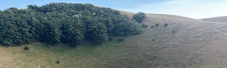
The Martani slopes have mainly gentle, with deep furrowed valleys, due to the presence of torrential streams that are dry for much of the year.
The high degree of permeability of the limestone rocks and the presence of the fault system have allowed the establishment of a deep and complex groundwater flow. In some cases, water erosion has produced very deep ravines, with sinkholes due the dissolution of limestone; there are also cavities and caves.
The tops of Martani are mostly rounded and grassy. The evergreen forests have primarily Holm, and also arbutus, terebinth, lentisk, mastic trees, heather, wild olives and the beautiful Aleppo pine.
As for the fauna, its diversification is linked to the variety of plant environments examined above.
Among the invertebrates are to remember two splendid insects: the two-tailed pasha butterfly (Charaxes jasius) a beautiful large diurnal butterfly characterized by typically tropical colors, unfortunately more and more rare, closely related to the strawberry tree (Arbutus unedo), a plant by which the caterpillar can survive; and the Rosalia longicorn (Rosalia alpina), a rare beetle, marked by a blue livery light with ash-dotted elytra by velvety black spots, which survives and blends into beech woods.


