


Don’t miss this path that is connecting two “monumental” pilgrimage destinations, Assisi and Loreto, it belongs to an old track that led up to Rome: pilgrims used to walk it to visit the Sanctuary of the Holy House of Mary in the Marche region small town. More than a pathway, it is an open – air museum of locations, routes and memoirs, 150 km long and divided into seven stages, each one of about 22 km. Because of its beautiful landscapes it will remain in your heart for many years.
We suggest you several stages of the Lauretano journey which wind through the Umbrian land and partially through the Marche region. You can follow all of them or just one, depending on your roadmap. The most important thing is that you choose to start during autumn or spring time, the better seasons for a barefoot adventure into the wild nature. An advice: be careful to the not always visible track. Just for a few months started the restoration works which include the arrangement of the wooden road marks and some totem indicating the route with historical and cultural information about the area.
Start from Assisi towards Spello through the National Road 444 and head to the Saint Benedetto al Subasio abbey. From here, with an over three hours walk for ten km with maximum height difference of 340 meters, you can enjoy the Subasio Mount coast, between coppice woods and olive groves, which is sending you on the plain below carrying you in no time above Spello and giving you a beautiful and unexpected view of the village.
The second stage, for the most trained and motivted ones, does go from Spello on the Colfiorito highland for more than eight hours walk with an uphill difference in height of about one thousand meters.
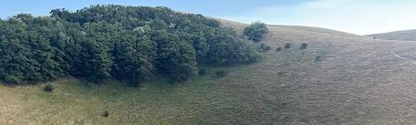
It is surely the most challenging stage of all the journey, 29 km long between dirt roads and wild paths, but you will appreciate this for its wonderful landscapes, which from the Spoleto Valley and from Spello’s hills they climb on the Apennine and they cross it. You will walk down several cultivated areas, higher woods and pastures up to touch the Colfiorito’s swamp, a precious casket of biodiversity.
We recommend a visit to the Church of Santa Maria di Plestia styled protoromanesque, located on the border between Umbria and Marche regions: this building is located at the Municipality of Serravalle di Chienti, while the churchyard is located at the Municipality of Foligno.
The third stage, after crossing Colfiorito’s plain and the upper part of the Chienti’s Valley, it goes in the Marche region. Now you can choose between two different paths of the Lauretana Way: one who lead to Camerino, for about 23 km and six hours of walking with an uphill difference in height of 600 meters, or that one to Muccia, 18 km for more than four and a half hours on foot with an uphill difference in height of 350 meters.
From here to Loreto there are still 80 km of walking passing through the villages of Belforte del Chienti, Tolentino and Macerata, but whatsoever be your decision – to keep going or to finish your road – you will feel better, in your body, in your mind and in your soul.
For more information:
https://camminilauretani.eu/
Credentials of the Pellegrino Lauretano (Lauretano Pilgrim) - (Charta Pelegrini Lauretani) shall be issued by the Confraternities of the Most Holy Stigmas of Saint Francis (www.sacrestimmate.it) at religious places specifically authorized or electronically, in cooperation with Opera Romana Pellegrinaggi too.


